By Shelby

Sunday, we drove an hour and a half to Capitol Reef National Park. Since Capitol Reef is one of the least popular national parks in Utah, we hadn’t expected to have trouble finding parking. Surprisingly, the parking lot was full when we arrived and we had to wait a few minutes for someone to leave. When we got a spot, we had a quick lunch in the car.
We hiked a 9.5 mile trail called Navajo Knobs up a large slanted land mass called a geologic monocline. It was a pretty tough hike since most of it was uphill. In exposed areas, it was very windy and I was almost blown over. Part of the hike was around a unique rock formation called the Castle.


The last part of the hike was pretty steep and the views were great. The very last section was up a smaller rocky peak. It was very windy and kind of scary, so I didn’t stay up there for long. The hike back down to the parking lot went a lot faster than the hike up. We saw several rainstorms in the distance and thankfully didn’t get wet on the way down.
After resting for a bit, we drove on to the scenic road going through the park. The large rock formations were very colorful. Part of the road went right through a canyon, which was unique. We parked at the end of the road to have dinner.


Our last stop of the day was a panoramic viewpoint where we could see the peak we had hiked to earlier. Then we drove on into the snowy mountains to our sleeping spot, Larb Hollow Lookout. It was very quiet, dark, and remote.
Unfortunately, we were woken up by a strange noise in the middle of the night. It sounded like something walking near the car. It was really creepy. We shined a flashlight around the car and saw a mouse on the floor of the front seat. We spent the rest of the night unsuccessfully trying to catch it and get it out. It seemed to stay in the front of the car and kept running away behind the dashboard and into the engine compartment.


The sunrise at the lookout was pretty nice, despite how tired we were. After quickly getting dressed, we drove on to Bryce Canyon National Park. We didn’t hear any more noises, so we hoped the mouse left.
The drive to Bryce Canyon was snowy and cold, so we were a little worried the day wouldn’t work out. The road progressively got worse as we increased in elevation, but we made it to the visitor center. After refilling our water bottles, we drove to the start of our hike.


We hiked the 3.5 mile Navajo Loop trail down into the hoodoos. The view from the start was really nice. The orange hoodoos covered with white snow looked pretty neat. Hoodoos are tall rock spires created by erosion over many years.
Despite the snow, we stayed warm with several layers and our good hiking boots. When the sun came out a few times we even got a little too hot. Because of the steep inclines of the trail, we used our microspikes to improve our grip in the snow. They were really helpful and fun to use.


The trail was a little too busy, but still really cool. We walked on ridges next to hoodoos and slowly descended to the bottom of the canyon. The hike back out of the canyon was pretty tough, with dozens of snowy switchbacks.
After the hike, we drove to a couple overlooks and ate lunch. Spencer opened up the hood of the car and unfortunately saw the mouse running around the engine. We were really disappointed it hadn’t left on its own. We ended up buying a couple mouse traps along the way to our sleeping spot at a rest area. At the rest area that night, we baited the traps with almond butter. We were shocked a while later when we saw the mouse standing on the trap eating the almond butter without the trap going off. We figured the mouse was too light to set it off. We set the trap again and tried to get some sleep. Eventually, the trap did work and we were able to get rid of the mouse.


Tuesday morning, we got up before sunrise and drove to a trailhead in Zion National Park. The Canyon Overlook trail was supposedly a good place to watch the sunrise and it was only about a mile round-trip. When we got there, parking was already filling up. We had expected lots of crowds at Zion and were worried about getting parking.
The trail was pretty neat, itself. It followed along a canyon wall and at one point, we had to walk over a small wood bridge. The sunrise was pretty good. There were lots of people there watching. We also had a great view of the canyon below. We could see the road we would be driving on further into the park. It had multiple switchbacks. We saw a lot of cars driving on it, which made us a little nervous about parking filling up. We hurried back to the car shortly after sunrise and drove on.


To get to the visitor center, we had to drive through the mile long Zion-Mount Carmel Tunnel, which was neat. Then we drove down the many switchbacks to the bottom of the canyon. Parking at the visitor center was definitely filling up, but luckily we got a spot. It was crazy how busy it was at only 8:30 in the morning.
Because Zion National Park gets so busy, they close the scenic road to traffic and run a shuttle system to transport people around the park. One of the only free places to park is at the visitor center, so we were glad to get parking. We got on the shuttle and went to our first stop, the trailhead for the West Rim trail.


The trail was intense. It was mostly uphill, with many steep switchbacks. There were amazing views of Zion Canyon. It was also very busy. There was a constant stream of people coming up and down. We were a little annoyed by so many people with poor trail etiquette, including large groups blocking the trail, kids running around us, and people yelling and shouting.
Near the end of the trail was a short section called Walter’s Wiggles, a series of short, steep switchbacks. It was strenuous but very cool. There was still a little snow on the trail, so we had to be careful not to slip.


The end of the trail was Scout’s Lookout where we saw the other side of the canyon. There was a sheer, almost 1500 foot drop down the cliffside which was dizzying to look at. The trail did continue further to Angel’s Landing, a very famous trail where you have to hold onto chains as you climb up a ridge with 1500 foot drops on either side of you. Because it’s so popular, you need to win a lottery to get a permit to hike it. I thought it would be too snowy and slippery to try, so we didn’t do it.
Our next stop in the park was the Narrows Riverside Walk, an easy 2 mile trail leading to the Narrows. The Narrows was another famous hike in Zion where you walk along the Virgin River into the canyon with the high canyon walls on either side of you. You need special gear, especially in winter, to do that hike since you will be wading in deep water, so we decided not to do it. It was enough for us to walk the riverside trail.


After the trail, we took the shuttle back to the car. It was still early in the afternoon, so we decided to drive on for four hours to Flagstaff, Arizona. We had planned on sleeping at a trailhead near Zion, but we had extra time and we wanted a shower. We made a quick stop at an overlook near the Colorado River to eat dinner. It was dark in Flagstaff by the time we arrived, but Arizona doesn’t observe Daylight Savings, so we gained an hour. We went right into Planet Fitness for showers and then pretty much went right to bed after that.
Wednesday, we did laundry, planned out the next couple days, and hung out at a local library. It was nice to take a break. Unfortunately, the charger for our battery power station blew a fuse that night in the middle of heating up dinner. We ended up getting fast food instead because the battery died and we couldn’t use the microwave. At Planet Fitness that night, we got knocked on by a street sweeper and had to drive across the street to sleep for the rest of the night.


Thursday morning, we picked up a replacement fuse, which fortunately worked despite being a slightly different size. Then we drove out of Flagstaff and headed to Winslow, Arizona. Winslow is famous for being in the Eagles song “Take it Easy”. The town had a statue and mural on the corner in the downtown area referencing the song. It was pretty cool. Route 66 also ran through Winslow. We were glad to get a chance to drive on it.
Our next stop was Petrified Forest National Park. It was very cold, windy, and a little rainy and snowy. It was all exposed with no trees to block the wind. The park had hills that reminded us of Badlands National Park, just a slightly different color.


We did a couple different trails throughout the park. The longest was the Historic Blue Forest Trail, which led into the multicolored hills. We could see scattered pieces of petrified wood. In one area, it looked like someone literally dumped a bunch of wood chips on the ground. But they were actually little pieces of rock.
Another trail we did was the Giant Logs trail, which led through very large pieces of petrified wood. It definitely seemed like there had been a forest there at one time. We also learned that dinosaurs once lived in the area.


When we finished with the park, we drove back towards Flagstaff. We stopped at a rest area to cook steak sandwiches. The sun had come out and it was warmer than it had been earlier. The sandwiches were easy to make and tasty. After eating, we hung out at the rest area for a bit before returning to Flagstaff for the night. We parked at a grocery store instead of Planet Fitness, so we wouldn’t get knocked on again.
Friday morning, we got breakfast at an old style route 66 diner. After breakfast, we got back on the road and drove a couple hours north to the Grand Canyon’s south rim. It’s unfortunate that the north rim closes in winter because we originally came from the north and it would have made sense to go there instead of the south rim.


After we got into the park and parked at the visitor center, we walked to the Mathers viewpoint, one of the most famous viewpoints of the canyon. It was very crowded, but we managed to get a picture together.
Then we took a shuttle to another viewpoint. We walked a couple miles along the rim. The further we got from shuttle stops, the less people there were, which was nice. Again, we were surprised at how crowded the park was in March. We had to wait in a long line to even get on the shuttle.


After walking a couple miles, we caught the shuttle again and returned to the visitor center. We were still pretty full from breakfast, so we only had a few snacks for lunch. Then we took a different shuttle to the South Kaibab Trailhead. We walked a little over a mile down into the canyon. The views were much better than they had been on the rim trail. It was also much less busy.
On the way down, we saw a bunch of people gathered around taking pictures of something. When we got closer, we saw a tiny mountain goat eating a bush. It was very cute.


We walked past Ooh Aah Point, where it seemed most people stopped and went back up. The views got even better. There was a section where we walked on a ridge that was very scenic. When we were satisfied with what we had seen, we began the long walk back up to the top of the canyon.
When we returned to the car, we drove to Lipan Point, supposedly one of the best places to watch the sunset over the canyon. We were fortunate to get parking because it was very busy. The sunset was nice. We ate dinner there before leaving and going back to Flagstaff. We had planned on sleeping on a national forest service road nearby, but there was more snow in the area than expected and the road was completely covered.


Saturday morning, we got back on the road again and drove north back into Utah to Monument Valley. Monument Valley is a famous valley with interesting rock formations. Lots of movies were filmed there, including Forrest Gump, one of my favorite movies. There were lots of people there taking pictures. Whenever the road was clear from cars, people would run into the road for a picture.
We made a quick stop at Mexican Hat, a rock formation that looked like an upside down sombrero. We made another stop at Valley of the Gods, an area with tall rock formations. There was a small stream going across the dirt road, so we turned around since we didn’t want to get stuck.


Our next stop was the Four Corners Monument, where Utah, Arizona, New Mexico, and Colorado meet in an intersection. It was in a tribal park in the Navajo Nation, so we had to pay an entry fee. Honestly, we didn’t think it was worth it. There was a marker in the middle of the monument with the state boundaries outlined and some vendors selling souvenirs. There really wasn’t much there.
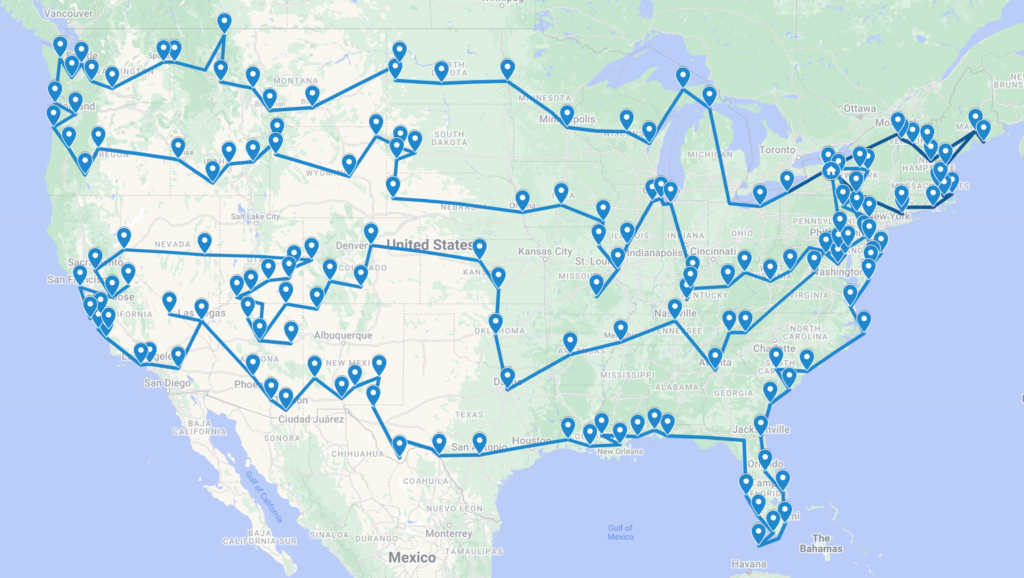
Our last stop was Farmington, New Mexico where we plan on working from next week. It’s been a crazy week. We did 7 national parks in 9 days! We also changed times 7 times since Daylight Savings started, since Arizona doesn’t observe it, but the Native American reservations do. Sunday we just cleaned the car and relaxed for the rest of the day.

Fun Facts from Week 47:
- The Zion-Mount Carmel Tunnel, completed in 1930, is 1.1 miles long. It was the longest tunnel of its type in the US at the time.
- There are 21 switchbacks on the Walter’s Wiggles section of the trail to Angel’s Landing at Zion National Park.
- The Grand Canyon is slightly larger in area than the state of Delaware.